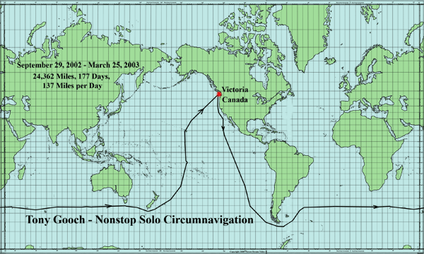
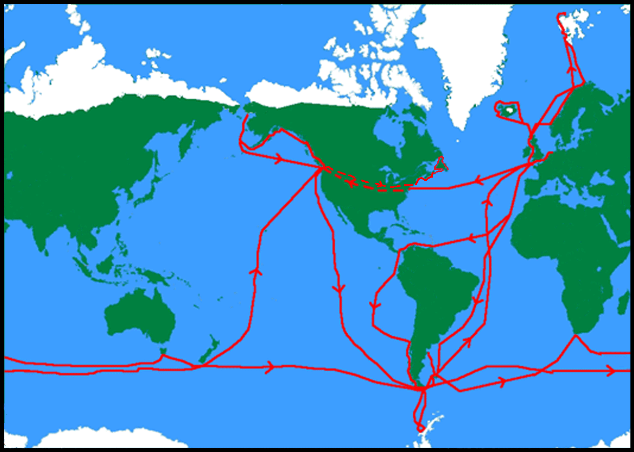
Tony Gooch
Non Stop Solo Circumnavigation
![]() Victoria
to Victoria
Victoria
to Victoria
September 29th, 2002 - March
25th, 2003
24,362 Miles, 177 Days, 137 Miles per Day
(5.708 knots), 0.98
νLWL
© Richard Konkolski
The idea for such a trip came up while Tony was returning from a
summer’s sailing in Spitsbergen
in 2001. He wanted to get down there one last time while he was still fit and
healthy enough to handle hard sailing and enjoy it all. Such a trip had never
been done from the west coast of North America so he decided to make the attempt
from his homeport of Victoria, British Columbia.
A non-stop circumnavigation from the west coast of North America poses a different set of navigational problems than those encountered on a similar trip starting from Europe. The best time to leave Victoria is the end of September in order to avoid the hurricane season off Central America and arrive at Cape Horn at the start of the southern summer, then spend the months from December to February circuiting the Southern Ocean. Unfortunately this means returning north up the South Pacific during the cyclone season.
Tony estimated that the trip would be about 27,000 miles and would take between 200-210 days at an average daily run of 135 miles. If he would left at the end of September he should be home before his wedding anniversary on April 29th, 2003.
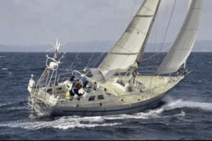
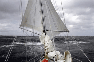
He crossed the starting line between his house and the lighthouse on Trial Island, just before noon on September 28th, 2002. He had on board enough food for 8 months and 210 cans of beer…a ration of one a day. The first 60 miles was a stiff beat down the Strait of Juan de Fuca and out to the open sea. He had expected strong North and NW winds down the west coast of the US, but in the event the winds were generally light all the way to the Doldrums at around 10 degrees north, and the average daily run for the first 3 weeks was a disappointing 125 miles.
 © Tony Gooch
He picked up the SE trades at 4N and sailed close hauled down longitude 117W. Gradually the wind backed to the east and then the northeast, as he was lifted down the western side of the South Pacific High. At 35S the wind had backed all the way to the northwest, and he was starting to feel the force of the fronts spinning north from the lows as they circled Antarctica at 50-55 degrees south.
At 42S, he saw a Wandering Albatross, a sure sign he was back in the Southern Ocean.
On November 18th he was at 47S with 1,080 miles to go to Cape Horn when the barometer dropped from 1008 to 990 in 15 hours. The Chilean weatherfax showed a large-area low moving northeast that would give strong southeast and then southerly winds for some time. He decided to lie to the drogue and let it all go by rather than sail close-hauled into such strong winds.
While he was getting the drogue out of the cockpit locker, Taonui was knocked flat by a large wave. He had time to turn his back to the wave and drape himself in front of the open cockpit locker, but still gallons of water went into the stern compartment. Fortunately, the companionway was shut, but the dorade over the navigation desk was open.
Later he found about an inch of water in the containers at the back of the navigation desk, and the radar tube, which was directly below the dorade, took a dunking. His heart sank when he pressed the display buttons and water squirted out, so he kept pressing until that stopped. Later he took the display unit apart and thankfully found it quite dry inside. It did stop working later in the trip, but that was for another reason.
The barometer stayed at 990 for 12 hours and the wind blew a steady 45-50 knots with gusts to 55. He lay to the drogue for 39 hours until the barometer rose to 1000 and the wind slowly shifted to the southwest.
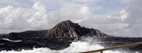
He had planned to pass about 90 miles south of the Horn to avoid the shallow bank that extends 70 miles south of Cape Horn. Here the depth rises from 13,000 feet to 300 feet in only 20 miles. In bad weather this bank produces horrific seas. As it happened, on November 26th, the winds were only 20- 25 knots from the west so He could sail over the bank and close along the shore of Cape Horn Island. He was lucky enough to see it in bright sunshine, with smooth seas and a dusting of new snow on the hills of the nearby islands.
 © Tony Gooch
Taonui had logged 7,457 miles since leaving Victoria 58 days previously. He felt a strong sense of gratitude, accomplishment and relief to have made it around Cape Horn. No longer was he sailing south and away from Victoria, now he was sailing for home.
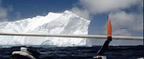
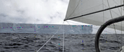
Just before leaving Victoria, he installed Sailmail on the boat. The components are a laptop computer, a Pactor modem and a SSB or Ham radio. The service costs $200 a year for an average daily transmission time of 10 minutes, which was ample for him to exchange emails every day with his wife Coryn. Coryn sent him weather information and lots of loving support and he sent daily reports which Coryn edited and posted on this website. Coryn relayed reports from the Argentinean Navy warning of considerable ice in the South Atlantic. Sure enough, on November 29 he saw what was to be the first of many icebergs.
 © Tony Gooch
A 20 x 50 mile piece of the Weddell Ice Sheet had broken off two years ago and the remnants were strewn over the South Atlantic, some as far north as Montevideo. Sometimes the icebergs were so numerous that there were always one or more on the radar screen. This cut down on his sleep time. A week later he came upon a monster “table” berg, perfectly flat on top and about 200 feet high. The two faces that he could see measured 6 miles and 4 miles on the radar.
 © Tony Gooch
It was a bright sunny day and he was able to sail quite close to this majestic piece of natural wonder.
Since leaving Cape Horn at 56S, he had eased north and by December 8th I was at 47S and appeared to have reached the northern limit of the icebergs, or so he hoped. He had planned to sail the Southern Ocean at around 44S. The lows seemed to be tracking along between 50 and 55S, so he stayed along altitude 47S for the next 7 weeks, using the weatherfaxes from Chile, South Africa and then Australia to monitor the progress of the
lows.
Additionally, Coryn emailed daily predictions from Meteo France and the NOAA weather forecast models that cover all oceans. Sailing along 47S as opposed to 44S cut about 1,500 miles from the distance to be sailed. Most of the time the wind oscillated from NW to SW, usually Force 6-7 occasionally Force 8 or 9. Sometimes it dropped to Force 3 or 4.
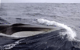
On one light wind day he had a visit from a Fin whale. Typically 85ft. long, the Fin is the second largest of all the whales, and he guessed this one to be 65ft. For 10 minutes he swam close to Taonui, surfacing off her stern and swimming alongside, then disappearing and sliding under Taonui to resurface on the other side and repeat the performance.
 © Tony Gooch
One of the pleasures of the Southern Ocean is the prolific bird life. He spent hours marveling at the effortless gliding flight of the albatross, particularly the Wandering Albatross. On a sad note, the population of albatross is in precipitous decline due to the irresponsible fishing practices of long-liners. The impact has been particularly devastating for the Wandering Albatross as they mate for life and raise only one chick every second year.
 © Tony Gooch
On December 25th he was at 47S 41E, just east of Marion Island and about halfway across the Indian Ocean. The seas were so light that I was becalmed for 4 hours. Santa, in cahoots with Coryn, had left a bag of presents and loving thoughts.
January 7th was definitely not a good day. In the morning, he rushed on deck in response to a loud bang and found the wind generator hanging on two wires. These soon snapped and the generator fell into the sea. Three weeks before he arrived back in Victoria the radar stopped working. When Tony got home he found there was a large hole in the back of the radar dome that was no doubt caused by the falling wind generator.
Later that same day, as the wind gusted to 50 knots, he decided to change down to just the staysail and in the process the #2 genoa became wrapped around its foil and before he could unwrap it the top half was blown to shreds. Fortunately he had a spare, slightly smaller jib, which he was later able to hoist in its place.
As he approached Australia, the lows were starting to move further north so he eased up to 45S for a week or so to keep some distance from the stronger winds at the center of the lows.
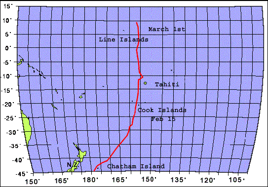
On January 15, Cape Leeuwin on the southwestern corner of Australia was about due north and he rode the northwest winds back down to 48S making a course for Snares Island at the south end of New Zealand. The passage south of Snares Island is not a good place to be in bad weather. He was lucky and passed over the shallow banks with a Force 6-7 from the southwest. The next day the New Zealand forecast was for 60+ knots at Snares! The distance sailed from Cape Horn to Snares was 9,553 miles covered in 63 days at an average speed of 152 miles a day. Although the Southern Ocean holds a compelling fascination, it is hard work and he was ready to head north.
He decided to cut the corner and head directly for Victoria rather than follow the planned route of sailing 2,000 miles further east to 150W before turning north. By February 1st he was up to 43S and beating into light NE winds to get around Chatham Island, which lies about 200 miles southeast of Wellington, NZ. He expected to be on a starboard tack for most of the next 7,000 miles to Victoria, so he shifted all moveable weight up to starboard. He set a course of 70 degrees True to a waypoint of 39N 150W, which he hoped would keep him clear of cyclones.
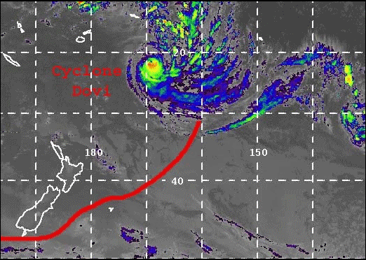
A large area of high pressure extended east from the Tasman Sea and for the next week or so he had some fine close hauled sailing in brisk East to SE winds. On February 6th, he was at 36S 166W and starting to worry about a cyclone named ‘Dovi’ that had developed at 18S 163W and as it moved south down longitude 169W. By February 8th, he was 360 miles east of Dovi’s centerline and 600 miles to the south.
 © Tony Gooch
With a double reefed main and staysail, he hung on to as much easting as possible as Dovi continued to move SSW and he sailed north. Finally on February 11, I was 600 miles east of the center of Dovi and the wind started to ease. By February 15th, the weather systems had returned to normal. The South Pacific High had reestablished itself and for 28 hours Taonui romped along on a broad reach under full main and asymmetrical chute making 7 knots. It was great for the morale to be moving again.
At noon on February 15, Mangaia, the southernmost of the Lower Cook Islands was a low grey lump in the ocean about 20 miles to starboard. Just being at the southern edge of French Polynesia gave a sense of progress. About 120 miles ahead were three more of the Cook Islands and after that clear sailing all the way to Hawaii.....2,500 miles away on a course of 10 degrees True.
 © Tony Gooch
Between 13S and 7N the sky was full of squalls with much rain and changeable winds requiring endless sail changes. The hot, muggy weather didn’t help, nor did a strong current of 1–2 knots setting to the SW between 2S and 10N.
On February 24th he somehow managed to catch the sacrificial strip of the # 1 genoa on the radar reflector on the mast resulting in an 11-foot rip down the leach. He decided not to take the time to repair it as he expected strong close-wind sailing for most of the rest of the trip. He crossed the Equator on February 27th at 156W and by 10N he was out of the squally weather and into the clean, clear northeast winds. With no adverse current and Force 5 –6 winds, the daily runs jumped from 135 miles to 155 miles a day.
He had hoped to pass east of the Hawaiian Islands, but ended up having to beat my way through the chain passing south of Maui in a light east wind and against a west going current.
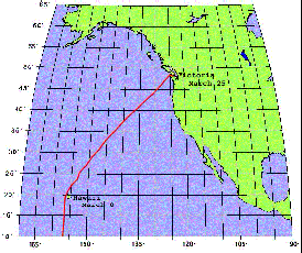
The trip from Hawaii to Victoria is usually a close reach against the NE winds until you are north of the center of the North Pacific High, at about 30 –35 North, and then a run to the coast on the SW to West winds. Again he was lucky with the weather. The High had
wandered off to sit over southern California and a continuous series of lows marched their way NE from Japan giving strong to gale force SW winds. He was able to sail a rhumb line course directly to Victoria. Having only one genoa he had to run wing and wing, rather than use poled out genoas.
At 0900 on March 19th a violent squall hit with 50+ knots of wind. Taonui rounded up and at the same time a larger wave hit her broadside. The boom dug into the water and the forward motion was such that the boom snapped at the vang. Tony was in the cockpit and watched it all happen as if in slow motion. A sickening sight and feeling. Luckily He had brought precut and drilled angle bar to fix a broken boom but he needed calmer weather to make the fix. With the squall the wind shifted into the NW and stayed at 35 – 40 knots for two days. All this pounding was coming from a 989 low that was taking its own sweet time tracking along 50N and into the Gulf of Alaska.
 © Tony Gooch
He spent most of March 21st repairing the boom, as it was likely that he would find east winds in the Strait of Juan de Fuca. As it turned out, on March 24th he had a stiff beat up the Strait much of it against an ebbing spring tide. That night the wind died so he took down the sails and waited till dawn.
Over thirty boats from the Yacht Club had come out to welcome him home, which was very heart warming after such a long time at sea. The last 10 miles were a real struggle, ending as a beat against a pale SE wind and an ebbing tide. He crossed the finish line off Trial Island at 11.00 a.m. Coryn jumped aboard and the local Coast Guard Auxiliary towed Taonui around to the Yacht Club.
The trip had taken 177 days. The distance sailed was 24,340 miles, at an average speed of 137 miles a day. Tony was very grateful to his wife, Coryn, for her role in this adventure. Aside from her help in preparing the boat and stocking her for the trip (including baking 8 large fruit cakes), Coryn spent hours updating the website, handling newspaper, radio and TV interviews. Every night she checked weather reports, thought them through and emailed him a summary along with warm chat and encouragement. A large part of this trip's success and Tony’s pleasure, enjoyment and sanity were due to her efforts and support.
Tony Gooch's Sailing
 © Tony Gooch
For more info visit: www.taonui.com
© Richard Konkolski
Return back to list of solo-circumnavigators
![]()